Chill Gone But Onshore Winds to Bring Temp. Fluctations... Controlled Burns... Plains Dust Storm
JIA had their first 32 degree morning since New Year's Eve, but
Southern & Eastern Duval Co. stayed above freezing where many (most)
places have yet to have a freeze this winter! The overall general
temp. trend is a warmer one over the next 7 days but with a caveat:
east to northeast onshore winds mainly Fri. & again Sun. Those two days will be cooler, especially closer to the coast. Otherwise Thu. will be around 70...as will Sat. A significant storm system will evolve over the Central U.S. by the middle of next week. In advance of this system, another big warm-up will spread across the Southeast U.S. & First Coast with highs well into the 70s. With any luck -- & early indications are indicating the possibility -- the system will stay intact enough when it reaches the Eastern U.S. to bring some much-needed rain to the First Coast. I'm not holding my breath, however, as long range models have had a history this season of being too robust too far south. The overall weather pattern is generally stormier the next couple weeks for the Lower 48 which gives us at least some hope for some rain.
'Tis the season for prescribed wildfires in the hopes of decreasing the "fuel" for wildfires in the spring. The photo below is from Cheryl Horn near the Intracoastal west of Crescent Beach in St. Johns Co. -- a controlled burn Wed. afternoon. The next image shows the wildfire danger which will be steadily increasing until & unless we get some decent rain. Click here for the Florida Forest Service website.


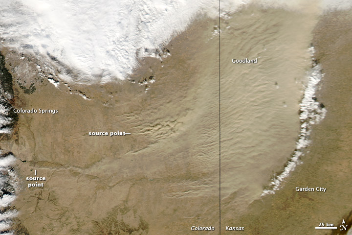
Speaking of dry weather, check out the recent dust storm on the plains of Colorado & Kansas courtesy NASA -- click here. The story:
A cold front pushed eastward across the continental United States in early 2013, passing through Colorado on January 11. Ahead of the cold front, a dust storm arose along the Colorado-Kansas border. The Moderate Resolution Imaging Spectroradiometer (MODIS) on NASA’s Aqua satellite captured this natural-color image on January 11, 2013.
Although the dust was thickest in western Kansas, many of the source points for the storm were in Colorado. One dust plume arose roughly 70 kilometers (40 miles) south of Colorado Springs. In Kansas, the eastern edge of the dust storm spanned 240 kilometers (150 miles) and the dust was thick enough to completely hide the land surface below, especially east of Goodland. Salina.com reported that the blowing dust reduced visibility to a quarter of a mile (0.4 kilometers).
Dust storms in this region have occurred in the midst of severe, lingering drought. As of January 8, 2013, the U.S. Drought Monitor described drought conditions in western Kansas and southeastern Colorado as “exceptional.” Asmaller dust storm struck the same region in November 2012. Photo below courtesy NASA "Earth Observatory".
east to northeast onshore winds mainly Fri. & again Sun. Those two days will be cooler, especially closer to the coast. Otherwise Thu. will be around 70...as will Sat. A significant storm system will evolve over the Central U.S. by the middle of next week. In advance of this system, another big warm-up will spread across the Southeast U.S. & First Coast with highs well into the 70s. With any luck -- & early indications are indicating the possibility -- the system will stay intact enough when it reaches the Eastern U.S. to bring some much-needed rain to the First Coast. I'm not holding my breath, however, as long range models have had a history this season of being too robust too far south. The overall weather pattern is generally stormier the next couple weeks for the Lower 48 which gives us at least some hope for some rain.
'Tis the season for prescribed wildfires in the hopes of decreasing the "fuel" for wildfires in the spring. The photo below is from Cheryl Horn near the Intracoastal west of Crescent Beach in St. Johns Co. -- a controlled burn Wed. afternoon. The next image shows the wildfire danger which will be steadily increasing until & unless we get some decent rain. Click here for the Florida Forest Service website.
Speaking of dry weather, check out the recent dust storm on the plains of Colorado & Kansas courtesy NASA -- click here. The story:
A cold front pushed eastward across the continental United States in early 2013, passing through Colorado on January 11. Ahead of the cold front, a dust storm arose along the Colorado-Kansas border. The Moderate Resolution Imaging Spectroradiometer (MODIS) on NASA’s Aqua satellite captured this natural-color image on January 11, 2013.
Although the dust was thickest in western Kansas, many of the source points for the storm were in Colorado. One dust plume arose roughly 70 kilometers (40 miles) south of Colorado Springs. In Kansas, the eastern edge of the dust storm spanned 240 kilometers (150 miles) and the dust was thick enough to completely hide the land surface below, especially east of Goodland. Salina.com reported that the blowing dust reduced visibility to a quarter of a mile (0.4 kilometers).
Dust storms in this region have occurred in the midst of severe, lingering drought. As of January 8, 2013, the U.S. Drought Monitor described drought conditions in western Kansas and southeastern Colorado as “exceptional.” Asmaller dust storm struck the same region in November 2012. Photo below courtesy NASA "Earth Observatory".
Copyright 2013 Cox Media Group, Inc. All rights
reserved. This material may not be published, broadcast, rewritten, or
redistributed.
No comments:
Post a Comment